(The following now has a companion piece, pieces in fact, expanding upon some of the issues raised by my discoveries to consider the landscape beyond the present limits of Puttenham Common: read the introductory post here, and main page of analysis here.)
Finally being able to get hold of free and easy-to-use LiDAR imagery online (via the houseprices.io website) has been one of the most exciting things to happen to my ongoing research into the early landscape of Puttenham parish. Why? Because within seconds of zooming in to the Puttenham area (some 95% of the parish area is covered by the freely-accessible online imagery, with only some jagged triangles of land on the Hog’s Back missing) I spotted what to my eyes looked a lot like linear boundary earthworks making up a lost field system at the east end of the Hillbury ridge on Puttenham Common. The more I looked, the more I saw: a separate set of boundaries to the west of the initial patch; another, fainter group to their north; and a series of parallel features on the opposite side of the Long Bottom valley, at the extreme north-eastern corner of the Common. Here is relevant excerpt the original image:

FIGURE 1: The northern half of Puttenham Common. In the centre of the image is the Hillbury ridge or plateau, with the earthworks of Hillbury marking its western end. To the north, the dry valley system of Long Bottom. In the top right corner is Lascombe House and Farm. Just visible in the bottom left corner is Hampton Lodge and Park.
And here’s the same image with the suggested features transcribed on it, along with a range of other bits and pieces for context (see caption for further details):

FIGURE 2: The suggested field systems on Puttenham Common. The boundaries of each one has been assigned a different colour to distinguish them from one another. Light blue denotes features of archaeological interest: the large polygon marks the probably Late Iron Age earthworks of Hillbury; squares mark the sites of Roman masonry buildings investigated by local antiquarian curate Rev. Charles Kerry in the 1860s and 1870s; circles are the approximate find-spots of Romano-British pottery picked by yours truly over the years. Selected current footpaths and bridleways are indicated by the stippled grey lines.
Each of the above four groupings will be discussed in turn below, with the mapped data supplemented by information gathered during a field visit made in good weather on the morning of 20th April 2016, before I move on to speculate on their age and outline future research priorities arising from this new set of discoveries.
“Eastern system”, east end of Hillbury ridge
This is the most extensive of the four, and from the looks of the LiDAR consists of the most substantial boundary earthworks. It is mostly covered by open grassland speckled with young deciduous trees, with a small patch of heathery heathland at its centre and more overgrown bracken-covered ground on its east; semi-mature deciduous woodland encroaches on two parts from the north. As it happens, I have had my suspicions there might be at least one boundary earthwork here for a good while now. About 15 years ago I borrowed a handheld GPS to try and plot its course on a 1:2500 OS map. The result (in the days before the restrictions in accuracy were lifted) was this:

FIGURE 3: My tentative plotting of what I’m now calling Boundary A (see below); more wobbly than in reality but more or less in the right place!
Whereas with the input from the LiDAR data I perceive all of this:

FIGURE 4: The eastern system, at the Murtmoor end of Hillbury Ridge; north is at the top of the image. As before, red denotes boundaries, and blue the sites of a Romano-British building (square) and pottery finds (circles). The yellow lines denote holloways, and the green square a WW2 fox-hole trench; both will be discussed in the dating section towards the end of this page.
My GPS-plotted boundary is the longest of the north-south elements of the system, and is a low but substantial physical feature, admittedly one that flatters to deceive when it comes to the straightness of its course. Let’s call it Boundary A, and use it to anchor the description of the rest of the system, starting with the features to its east, which is lower than that on its western side. At its eastern end, the northern limit partly coincides with – and actually accentuates – a natural break in slope between the ridge and upper reaches of the Long Bottom valley. It was here, in the soil brought to the surface by a burrowing rabbit, that I picked up the large but abraded sherd of pottery that represents just over half of the base of a late 1st or 2nd-century CE vessel shown in Figure 5 (and denoted on Figure 4 by the upper right-hand of the two dots).
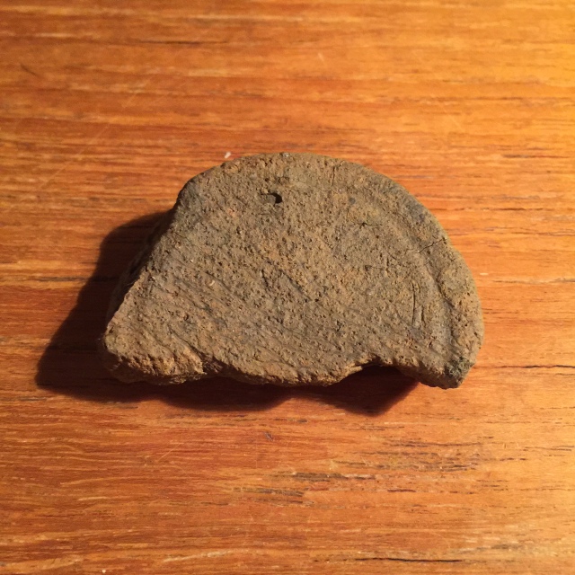
FIGURE 5: Underside of sherd from the base of a wheel-thrown Romano-British pottery vessel, in a coarse sandy ware of later 1st or 2nd century CE date (compare with description of fabric of sherds H1-H8 in Clark & Nichols 1960, 57-58)
Heading west, the boundary peels off from hugging the contour to run across more gently shelving open ground where it is identifiable as a low lynchet-like feature, but becomes very difficult to trace as it reenters woodland due east of Boundary A. Of the two boundaries of roughly the same length and orientation to the south, the middle one is not easily traced, although can be seen nearer its eastern limit where it is crossed by a footpath formed within the last 10 years. There is a distinct “bump” (more appreciable on the ground than in Figure 6, it must be said!) where its above-ground remnants force the path to rise up and over it – one of several such instances on the Hillbury ridge.
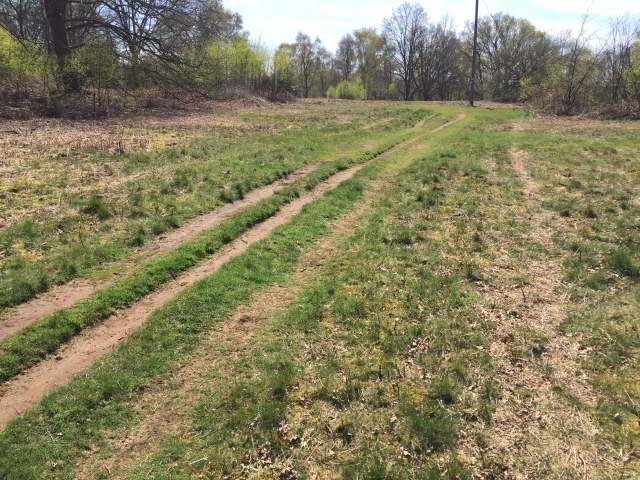
FIGURE 6: Puttenham Common problems! What I take to be the one of the east-west boundaries of the “eastern system”, perceptible in this photo as the point (approximate NGR SU 91844684) where the two parallel eroded paths coming in from the bottom left of frame suddenly narrow – this represents the point where they go down the far side of the low bank.
The more southerly of these two boundaries was perhaps the biggest and most welcome surprise from my site visit, because hitherto I had failed to appreciate its existence despite its quite substantial nature. Towards its eastern limit, this boundary survives as a lynchet standing the best part of a metre high, and even 150 metres further west can still be discerned as a sudden change in the steepness of the footpath running along the southern edge of the Hillbury ridgetop (Figure 7; the path in question is not marked on Figure 2). Beyond its junction with Boundary A, its continuation is harder to follow on the ground.

FIGURE 7: View of southern boundary bank of the “eastern system”, near its east end, where it is crossed by a footpath (approximate NGR SU 91824675). The lynchet-like form of the boundary is (hopefully) appreciable in this picture.
The east-west oriented boundaries west of Boundary A are a fugitive bunch. Those ones closest together on the north side of the ridge are all but impossible to trace on the ground, at least for my inexpert eyes. To their north-west lies the site of what may be the earlier of the two Roman buildings investigated by Kerry, whose site is known to have been ploughed for a brief period from 1947 (Clark & Nichols 1960, 47). It may be that they were considerably reduced by ploughing – I’ll return to this point later on. The western limit of the system (Boundary B, if you will) is more readily apparent as a low, spread-out bank running across the open grassland as far as the main east-west path along the Hillbury ridge. West of Boundary B the land is flat and featureless, but where the ground has been eroded by footpaths there is clearly a much higher proportion of flint and chert pebbles within the sandy soils. Might this represent ground that was less suitable for ploughing (at least before the post-War phase of cultivation) and/or did not undergo such intensive field picking of stones?
“Western system”, towards west end of Hillbury ridge

FIGURE 8: The “western system”, towards the Hillbury end of the eponymus ridge-cum-plateau. Again, north is to the top of the figure. Suggested boundaries are in dark blue. The light blue features on the left-hand side are the eastern ramparts of Hillbury, while the blue square denotes the site of the lower and potentially later of the two Roman buildings investigated and recorded in a fashion by Kerry.
By contrast with its eastern counterpart, this second system is smaller in size and its constituent elements appear much fainter on the LiDAR imagery. However, on the ground, it turned out that in places its physical remains, though slight, may extend beyond what is picked up by LiDAR. It helps that the land in question is largely open, a mix of rough grassland and heather (some of which derives from heathland restoration experiments conducted in the 1990s, involving some movement of earth hereabouts but seemingly without damaging any of the suggested boundaries) with a small patch of recent deciduous woodland on its northern fringe.
The north-south oriented boundaries are the more easily traced elements of the western system. Indeed, the lines of a couple are bisected by the main east-west Hillbury ridge path and slight humps in it coincide with them. Unfortunately, vegetation cover makes it hard to ascertain whether these continue north of the path. The one exception to this is the westernmost boundary of the system (or at least what I have identified as this system), set well clear of the eastern rampart of Hillbury and on a different alignment to it. It is the highest of the boundaries, and runs for the longest before coming to an end not so far away from what is usually considered to be the original main entrance to Hillbury at its north-east corner. Hints on the LiDAR that a slighter, curved boundary extends further north are something I need to investigate on the ground – for safety’s sake I have not included it in my transcription.

FIGURE 9: View looking south along the western boundary of the “western system”. Hard to spot until you look at the way there is a definite change in the horizon line in the centre frame, just to the left of the Scots Pine tree. Hillbury is out of shot to the right (photo taken from approximate NGR SU 91214685).
One thing that does mark out the “western system” from the others I am proposing here is the long, narrow gap in the middle of it. I feel like Figure 8 makes this feature look more tapered than in the LiDAR imagery, but either way, I do wonder if this might be commensurate with a north-south trackway running between the enclosures. To its south are suggestions of a holloway leading down off the ridge to a massive earthen berm where several paths meet to cross the damp valley bottom. In the opposite direction, I had hoped that extending its line would show that it was oriented on the lower and possibly later of the two Roman building sites known to us thanks to the explorations of Kerry. As you can see from Figure 8, this isn’t the case, but nor is the line all that far away from the site, so a link between them may not be out of the question (cf. discussion of “field ways” in Hampton & Hawkins 1984, 154, and more recently English 2013a, 32).
“Long Bottom system”, northern edge of Hillbury ridge
The third of the field systems is also the faintest, both on the LiDAR imagery and on the ground. My transcription of its boundaries goes something like this:
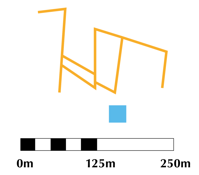
FIGURE 10: The “Long Bottom system” on the northern slopes of Hillbury ridge. North is at the top of the image. Transcribed boundaries are in orange, while the blue square denotes the lower Roman building site investigated by Kerry.
The predominant vegetation cover of bracken with a fair few trees and thorn bushes does little to help tracing any above-ground physical remains. None of what could be described as the north-south aligned boundaries were at all apparent to me when I walked across the area. The north-eastern boundary of the system coincides with a substantial lynchet-like feature on southern lip of Long Bottom (Figure 11), one that grows in stature the further east you go. There’s a strong likelihood that it’s a natural slope whose profile and steepness has been exaggerated by one or more period of cultivation. This bank aside, it’s hard to find any signs of the boundaries suggested by LiDAR hereabouts. Even so, the proximity of this system to the lower of the two suggested Roman buildings remains something worthy of note.

FIGURE 11: My “Big Bank Theory” is that this sharp break of slope (approximate NGR SU 91414721) is partly artificial, created by the downhill movement of soil arising from the cultivation of the land above. Nice old thorn tree, too, one of several in this part of the Common.
“Lascombe system”, north-east corner of Puttenham Common
It is possible that the first three systems are in fact fragments of a single extensive field system whose central section was destroyed by ploughing in the 1940s (and any other destructive activities that occurred in the years since the system fell out of use). However, in topographical terms, we appear to have a separate system on the other side of Long Bottom within sight of Lascombe House, hence the name used above. It is almost certainly a fragment of a larger original whole that extended further north. What does survive of it gives a sense that it was different in form to those sections described above because, as delineated in Figure 12, it consists of four enclosures of roughly equal width in the east-west dimension.
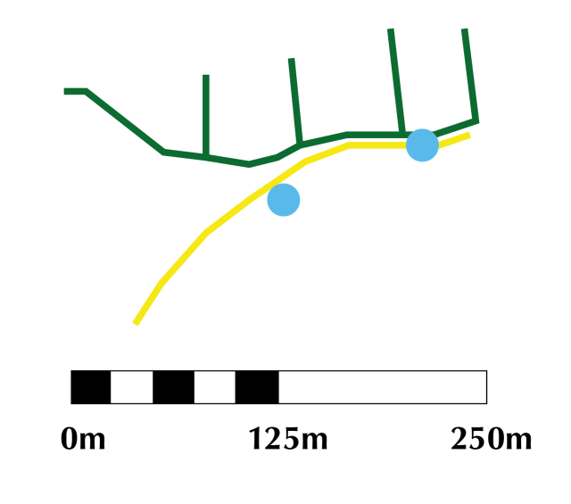
FIGURE 12: The “Lascombe system” in the north-eastern corner of Puttenham Common. North is at the top of the image. Suggested field boundaries are depicted in dark green. The yellow line is a holloway, and the blue circles find-spots of probable Romano-British pottery.
That this system, however truncated it may be, went undetected for so long is astonishing given it sits adjacent to (and indeed is partly crossed by) the North Downs Way national path. It can be broadly divided into two elements. The first of these are the four north-south aligned boundaries, the western pair of which take a lynchet-like form, whereas their easterly counterparts are low, wide banks; these differences reflect the degree to which the ground slopes. It’s worth highlighting that the easternmost boundary is set well clear of the eastern boundary of the Common, with no hint on the LiDAR or ground that the system continued any further east.

FIGURE 13: Rather like Figure 6, the thinning of the parallel footpaths above marks the point where they pass the top of a former field boundary – in this case the second easternmost of the “Lascombe system” (approximate NGR SU 91704473). I like to think this photo brings out the not-inconsiderable size of this low banked feature as it runs southwards.
This brings me nicely onto the second element of the “Lascombe system”; its southern boundary. At its eastern and western ends, this exists as a holloway, whereas in between it takes the form of a hefty berm, wide but not very tall. I’m not sure why I chose to mark the south-eastern boundary of the field system separately to the holloway in Figure 12, and omit the separate one at its western extremity – oh well, my bad. The holloway I have marked has been attributed a Roman by some locals (Currie 2001b, 98-99), although it may just as easily be a later innovation negotiating the remnants of the field-system earthworks. My recovery on or close to its route of two very small and abraded sherds of what I take to be Romano-British pottery similarly cannot be taken as diagnostic dating evidence.
A few quick words about other parts of Puttenham Common
It is very interesting to note from the LiDAR imagery (Figure 14 below) that there are no signs of any comparable features to those atop the Hillbury ridge and on flanks of Long Bottom surviving in the southern half of the Common, i.e. south of Hillbury ridge to the edge of the Common along Suffield Lane. Extensive holloway systems are picked up by LiDAR and are readily traced on the ground, proving that earthwork-type features are present in the area, whatever damage may have been wrought by subsequent land-use (there is no record of ploughing here, only of a rifle range used by Charterhouse School in the later 19th and earlier 20th centuries: Currie 2001a, 38). Traces of modest linear banks and ditches have been identified on the northern side of a small stream feeding into the early 19th-century pond known as The Tarn (Currie 2001b, 94-95); notably, these are not picked up by LiDAR, although tree cover is greater here than in adjacent areas.

FIGURE 14: LiDAR image of the southern half of Puttenham Common, with north at the top. The string of lakes associated with Hampton Lodge can be seen on the left side of both the image and the Common; the one in the bottom left-hand corner is The Tarn. The sub-circular feature in the south-eastern corner of The Common is the Top Car Park, almost due south of which is Rodsall Manor, approximate location of the Domesday estate centre of Redessolham. Multiple holloway systems are clearly visible north-west of the Top Car Park and east of The Tarn; both are likely to represent former cross-common routes, probably medieval in date, between Puttenham and Lower Puttenham Common and/or Elstead beyond.
In fact, much the same can be said Lower Puttenham Common as well (Figure 15), a marginal area mixing dry heath with damp grass and woodland in the southern limb of the parish. The lack of boundary-like features in both areas would point to a lack of cultivation, or at least of land enclosure by means of earth banks, perhaps consonant with use for pasture and/or woodland. (Little Common, a short distance to the north-east of the main section of Puttenham Common and due north of Lascombe House, is too intercut by short, deep valleys to have ever had sufficient suitable land for enclosure and cultivation.)
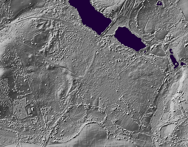
FIGURE 15: LiDAR image of Lower Puttenham Common and surroundings. For orientation, The Tarn is the larger of the two lakes at the top of the image. To its east is Cutt Mill Pond and House. In the lower left corner is the Britty Hill water pumping station, and bottom right is the hamlet of Gatwick. A few holloways can be seen, particularly on the western side of the Lower Common, but the most obvious features are areas of what I’m tempted to call natural stabilised sand dunes. The vaguely slug-shaped (!) enclosure at the southern edge of the common land is Halesmoor Wood, inside which the lines of three pond bays or dams of unknown date (but known to have been in existence in 1765) can be seen.
Date of the field systems
Despite Surrey generally being understood to be deficient relative to other counties in the physical evidence of early field systems, surviving either as earthwork complexes or as crop marks, dig deep enough and you can amass a considerable body of published material on the subject. However, without excavation, pre-modern field systems are tricky to pin down in time as far as their origins are concerned – the same applies even with excavation in some cases (e.g. Prest & Parrish 1950; Hampton & Hawkins 1984). In the acknowledgement that it is quite possible the field system remnants on Puttenham Common identified and described above do not all belong to the same period, are there ways of ascribing their origins to a particular period – or periods?
I’ve toyed with several ways of discussing the possibilities, and I think that in the name of consistency the best is to do so in retrogressive chronological order. This also allows me straight away to express a debt of gratitude to my mother for a brilliant piece of playing devil’s advocate. I’d been explaining to her what I’d identified and what I thought it all represented, stressing the likely antiquity of the evidence. Her response was simple and to-the-point: “Couldn’t they be modern?” Puttenham Common was used for military purposes during the Second World War, either as a training area or the site of emplacements for anti-aircraft guns and searchlights (or very possibly both: see Currie 2001a, 38; Currie 2001b, 57; Dugmore 1972, 132). In 1947, the Hillbury ridge was ploughed to grow potatoes. Clark & Nichols (1960, 47) pithily described the latter as ‘more productive of antiquities than potatoes’. Be that as it may, it is not impossible that the boundaries may belong to the short-lived phase of mid-20th-century cultivation.

FIGURE 16: Probable Second World War-era dug out gun emplacement, marked on Figure 4 at the northern extremity of the “eastern system” (approximate NGR SU 91604695).
A number of things suggest this is not the case. For starters, the extent of this brief period of ploughing is unclear. That it took in Kerry’s apparent villa site midway along the northern edge of the Hillbury “plateau”, where there are no perceptible earthworks, is beyond doubt, for Clark & Nichols (1960, 47) recorded Roman-era finds were made ‘at Kerry’s site’. Still, the ploughing phase – and any associated physical land divisions – may not have encompassed the whole of the ridge top. To my mind, it seems likely that cultivation did not take in those areas where heather survives, particularly in an around the “western system”. The survival of three Second World War-era “dug-out” trenches within some of the enclosures of the “eastern system”, including the one in Figure 16 (whose approximate location is marked on Figure 4), is noteworthy (see further Currie 2001b, 57). Even more so is the cutting of two boundaries within the same system by a double holloway that originated as a carriageway associated with Hampton Park, which was turned into a mansion in the final third of the 18th century (Dugmore 1972, 68; for the location of the holloways, see Figure 4).
A terminus ante quem of the late 18th century for at least the “eastern system” does admit the possibility that the enclosures are medieval or early post-medieval in date. It’s hard to prove or disprove this through documentary testimony, because the latter is so poor for non-demesne land in Puttenham before the 1765 Parish Terrier. South-east of the “eastern system”, beyond the eastern boundary of the Common (the same today as it was in 1765), were a group of fields whose names derived from Middle English breche, “land broken up for cultivation”, which is usually taken to denote ground late to be enclosed. We can be fairly sure one of these was a close named Breches in existence in the later 16th century, although this did not even abut the Common’s east boundary.
What may be telling here is that, in all my years of walking across the ground in question, especially that encompassed by the “eastern” and “Lascombe” systems, I’ve found plenty of prehistoric struck flints and around half a dozen of pieces of Romano-British pottery (mapped in Figure 2 etc., about which more in due course), but not so much as a single sherd of medieval pottery, which might otherwise be expected as testament to the manuring of the ground to improve its fertility. Compare this with the fields east of Lascombe, some 300 metres or so to the east, from which I’ve collected a smaller number of flints and a couple of bits of Roman-era pottery, but also plenty of medieval pottery (the earliest probably of 12th-century date) deriving from manuring practised on account of its cultivation as part of High Field, one of Puttenham’s open fields.
An earlier medieval origin is hard to credit given the marginality of Puttenham parish as a whole in this period (this is a topic I *will* cover in greater length in this page’s fraternal twin post). A Roman-era origin, by contrast, is more conceivable. Leaving aside my own handful of pottery finds, there is a plentiful assemblage of 1st to 3rd-century CE material from the Hillbury ridge on published record alongside other stray references in Kerry’s manuscripts (Clark & Nichols 1960, 46-47, 57-60, 62-63; Bierton 1990, 98-99; Currie 2001a, 19-20). It is generally contended that the upper of Kerry’s two sites (Figure 17), where his finds of ‘pavements’ are taken to stand for the remains of a masonry building, was that of a villa of the late 1st to very early 3rd century, and the lower (and less extensively investigated) site possibly another villa, perhaps of later date (see Briggs 2013, 2, for a short discussion). Both lie outside yet close to some of the field systems, but this does not necessarily indicate symbiosis; the networks of field boundaries could have been redundant features in the landscape by the time construction of the first Roman building began.

FIGURE 17: Present state of Kerry’s upper site, likely location of the first Roman masonry building-cum-villa on the Hillbury ridge. Note the size of the oak trees, which, following Clark & Nichols (1960, 47), can be no younger than the year 1947.
The building at Kerry’s upper site is briefly mentioned in David Bird’s book Roman Surrey, where its situation is cited as possible evidence of Roman-period soil exhaustion leading to the generation of heathland (Bird 2004, 77). The newly-identified field systems could be taken as supportive of the hypothesis. Elsewhere in the book, it’s notable/lamentable/inevitable that, for want of evidence, the discussion of the evidence of field systems in the historic county area doesn’t even run to one full page, and moreover includes the concession that some may not even be Roman in origin, merely utilised during the period (Bird 2004, 84). Considerably more insightful and relevant here is his highlighting of ‘some evidence to suggest that there was a considerable change in the landscape’ circa 200 CE, which could be perceptible in the morphology of the “main section” and “Lascombe section” in particular:
‘This saw the pattern of irregular fields which had continued from the Iron Age change to one of rectangular fields, about twice as long as broad.’ (Bird 2004, 85)
A few of the suggested fields on Puttenham Common match Bird’s description of later Roman ones, but over all, with the exception of the “Lascombe system”, it is the irregularity of the boundary patterns that really stands out. An Iron Age genesis is worth considering all the more because of the proximity of Hillbury (Figure 18), a poorly-understood univallate earthwork enclosure at the western extremity of the eponymous ridge that in recent decades has usually been interpreted as an Iron Age hillfort (Currie 2001a, 18). I believe Hillbury represents a very Late Iron Age enclosed settlement built in the hillfort tradition but not serving the same range of functions as precursors like Hascombe and Caesar’s Camp near Farnham; instead it acted as a pioneer settlement to (re)colonise a fertile but under-exploited region (Briggs 2013, 2).

FIGURE 18: The earliest known plan of Hillbury, published in 1836 on page 71 of Henry Lawes Long’s Observations Upon Certain Roman Roads and Towns in the South of Britain. Long lived at nearby Hampton Lodge, and was the first recorded investigator of Kerry’s upper site. Several details of the Hillbury plan, notably the lack of gateways and the substantial western rampart, reveal this was a schematic plan. Was it perhaps intended as a hypothetical reconstruction of Hillbury’s original form?
The trouble with the concept of a link between Hillbury and the adjacent field system earthworks is that there is a clear spatial separation. Even the “western system” betrays no sign of ever having extended as far as Hillbury’s eastern rampart, nor is its western boundary on the same orientation as the aforementioned. Whether these facts alone are enough to rule out a Late Iron Age date for all of the proposed field systems is open to debate – but the lack of integration and co-orientation cannot be ignored, and encourages the examination (and maybe preference) of other possibilities.
Pushing further back, none of the suggested Puttenham Common systems bears a resemblance to the recently-identified field system earthworks at Willey Farm, Chaldon, on the scarp slope of North Downs in East Surrey. These consist of a series of “looped” enclosures with rounded corners plus a number of contour lynchets; the former have been tentatively ascribed on morphological grounds to the Late Bronze Age/Early Iron Age, and the latter to either the Late Bronze Age or medieval period (English 2013b). Ruling out a possible period of origin on blunt morphological criteria may not be the best way of determining the date of the Puttenham Common systems, but my instincts are telling me to look elsewhere…
…which brings us to the Middle Bronze Age. In a wide-ranging, sometimes freewheeling chapter on the landscapes of prehistoric Surrey and their vestiges, David Field makes several references to ‘Celtic’ fields, which he attributes to the Middle Bronze Age on the basis of evidence from Wiltshire (e.g. Field 2004, 45). His main criterium for a field (system) being ‘Celtic’ is ‘the almost consistent orientation … on a north-east/south-west/north-west/south-east axis’ (Field 2004, 44). He notes a small number of proven or probable examples in Surrey, as well as ‘the great potential for further discoveries in the wooded areas on the summit of the [North] Downs’ (Field 2004, 46). None of the suggested field boundaries on Puttenham Common can be said to adhere to this definition.

FIGURE 19: The Whitmoor Common field system earthworks and other features. The mix of narrow and wide enclosures bears analogy with the combined morphology of the suggested Puttenham Common field systems. (From English 2000, 6)
The evidence for Bronze Age and Early Iron Age field systems (and more) has recently become a lot better understood thanks to the industries of Judie English, whose monograph based upon her PhD research was published in 2013 (English 2013a). Her study dedicates the majority of a chapter to the discussion of field system earthworks at Whitmoor Common, Worplesdon, and either side of the Mole Gap in Surrey. The Whitmoor Common system (Figure 19) is the better studied and understood, with the extensive coaxial series of extant earthwork boundaries partly underlain by an earlier, Middle Bronze Age phase traced through excavation and dated by radiocarbon dating (English 2013a, 27-33, building upon English 2000). It is noteworthy that, while both the Whitmoor Common system and those non-contour lynchet-based equivalents either side of the Mole Gap (English 2013a, 33-36) correspond to Field’s ‘Celtic’ fields, English avoids describing them using the same word.
A theme common to Field’s and English’s analyses is the potential for elements of Bronze Age field systems to endure and influence later patterns of enclosures and land use. Field notes how ‘”Celtic” fields are invariably re-utilized as fields long after their initial period of use … particularly in the Roman period when fields are enlarged and cross-divisions ploughed through’ (Field 2004, 45). He instances the Mole Gap systems, which probably pre-date the scatters of Early Iron Age and Romano-British pottery found within them (Field 2004, 46; cf. English 2013a, 33-34). English cites Woodcorner Farm north of Whitmoor Common as an area where modern field boundaries are on the same alignment as those of the relict Bronze Age field system, before segueing into the following observation:
‘Boundaries, fossilized in the landscape, could be seen as convenient and re-used at any period and many, if not most field systems have probably been reused’ (English 2013a, 149)
The abraded Romano-British pottery fragments, proximate Roman buildings and Hillbury earthworks therefore may all be immaterial when it comes to pinning down the origins of the Puttenham Common field systems. Field’s comment on the remodelling and enlargement of Bronze Age fields during the Roman period, on the other hand, has particularly relevance here given the irregularity of the – not least the exceptionally large north-eastern enclosure of the “eastern system” (Figure 4). One or two flints aside (Currie 2001a, 17, 18), there’s little recorded Bronze Age material from the Hillbury ridge. Whimster (1931, 120) claimed the south-east corner of the Hillbury earthworks was ‘conspicuous enough … to have been a tumulus’, which can be read as standing for a Bronze Age barrow. This has been disproved by later topographic survey (Graham & Graham 2001, 9), so the lack of integration with surviving (suggested) boundaries is neither here nor there. But a lack of features or artefacts cannot of itself count against a Bronze Age dating. There is a general lack of Bronze Age portable material culture from Puttenham parish, host to one and formerly two round barrows (ascribed Early Bronze Age dates in English 2013a, 156), although a recent find of mine from the south-east corner of Puttenham Common has started to change this picture…

FIGURE 20: Sherd of handmade Bronze Age pottery, found in rainwater-cut gully on footpath running east from Puttenham Common Top Car Park, January 2016
The careful consideration of the available evidence pertaining to the four sets of coaxial linear features identified in the northern half of Puttenham Common leads me to conclude that the strongest likelihood – but still some way off being the only credible interpretation – is that they are of Bronze Age origin, more specifically Middle Bronze Age. This does not mean that some of the suggested systems (notably the “Lascombe system”) or component enclosures or boundaries may not be of a completely different origin. Areas covered by Bronze Age field systems experienced repeated phases of cultivation in later periods, during which boundaries could have been removed or added as per the requirements of the cultivators. Thus to think of the Puttenham Common field earthworks as single-phase systems may be a gross simplification, and they in fact could incorporate elements from Iron Age, Romano-British and just possibly even mid-20th century phases of activity. Only carefully targeted excavation and sampling can hope to untangle the truth behind the faint boundary patterns perceptible in the present day.
Next steps
First priority must be a full survey of the earthworks on Puttenham Common picked up by LiDAR. It’s one thing to trace some linear features on a screen, quite another to get a representative real-life picture of them through careful field survey. One only has to look at what’s been achieved at Whitmoor Common (English 2013a, 28 Fig. 3.5) and either side of the Mole Gap (English 2013a, 34 Fig. 3.8) to realise what is possible where field systems are surveyed and mapped – the results are far superior to what’s picked up by LiDAR (or at least what can be extracted from the imagery available online). It may well be the case that further remnants of the suggested field systems, or entirely “new” equivalents, may be identified as a result of such activity. New discoveries may also result from the consultation of aerial photographs of the area, on top of confirmation that some of the features were in existence at a specific point in time.
While I am reasonably confident my analysis has given reason to doubt a modern origin for the earthworks that are the subject of this page, it would be advantageous to undertake oral historical research among long-standing residents of the locality to establish the location and extent of early post-War ploughing atop the Hillbury ridge. This would confirm whether any of the suggested boundaries/enclosures may be of mid-20th-century origin.
Thirdly, the Puttenham Common field systems must not be viewed in isolation, for there is evidence of other possible field systems in and around Puttenham parish. East of Lascombe, in the fields between Highfield Lane and Little Common, unpublished crop-mark transcription from an aerial photograph plus limited resistivity survey by members of the Surrey Archaeological Society’s Roman Studies Group has indicated the existence of a complex of boundary features that may represent a series of fields perhaps lining an enclosed east-west trackway. Romano-British pottery is on record from the vicinity (Bierton 1990, 102), but does this make the features contemporaneous, or is a later prehistoric origin again more likely? Hints of field system earthworks on Romping Downs in the Ash Ranges military training area have been noted (English & Dyer 2001, 7) but have yet to be subject of proper survey or excavation.
At the northern limits of Puttenham parish, atop the chalk ridge of the Hog’s Back, there are a variety of hints of another field system of considerable antiquity. Here, an area of former common grazing land was known as (The) Common Lints, a name which comes from Old English hlinc, ‘bank, terrace’ (or its Middle English equivalent link(e), linch(e)), and almost certainly refers to a substantial lynchet of unknown date running along the southern fringe of the area. Moreover, when a continuous trench was dug parallel with the southern carriageway of the A31 circa 2007/8 to prevent access to the common land by travellers, I noted what looked a lot like an infilled ditch in the cut at one point (but I didn’t think to work out its grid reference though, did I?). I fancy this “Common Lints system”, if it is permissible to talk in such terms, might be brought into view once more by magnetometry or similar surveying techniques. (We might also bear in mind the possibility that the lost “Seven Ditches” at the extreme north-west corner of the parish once formed part of a field system; I suggested something along these lines – albeit linking them to land divisions associated with Hillbury – a few years ago.)
All in all, plenty more work awaits…
REFERENCES (hyperlinked if available for free online)
Bird, D., Roman Surrey (Stroud: Tempus, 2004)
Clark, A., & J. F. Nichols, ‘Romano-British Farms South of the Hog’s Back’, SyAC, 57 (1960), 42-71
Dugmore, R., Puttenham under the Hog’s Back (Chichester: Phillimore, 1972)
English, J., Pattern and Progress: Field Systems of the Second and Early First Millennium BC in Southern Britain, BAR British Series, 587 (Oxford: Archaeopress, 2013) [= English 2013a]
English, J., ‘A probable prehistoric field system at Willey Farm, Chaldon’, SyAS Bulletin, 442 (2013), 13-14 [= English 2013b]
English, J., ‘Landscape Survey of Whitmoor Common, Worplesdon’, SyAS Bulletin, 342 (2000), 5-7
English, J., & S. Dyer, ‘Surrey Heathlands Project – Ash Ranges Survey’, SyAS Bulletin, 345 (2001), 5-7
Field, D., ‘Engraved sequences and the perception of prehistoric country in south-east England’ in Aspects of Archaeology and History in Surrey: towards a Research Framework for the County, ed. by J. Cotton, G. Crocker and A. Graham (Guildford: Surrey Archaeological Society, 2004), 39-49
Graham, D., & A. Graham, ‘A Survey of Hillbury Camp, Puttenham Common (SU 9115 4680)’, SyAS Bulletin 346 (2001), 8-10
Whimster, D. C., The Archaeology of Surrey (London: Methuen & Co., 1931)

